#include <HorizontalMapFunction.hpp>
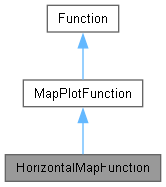
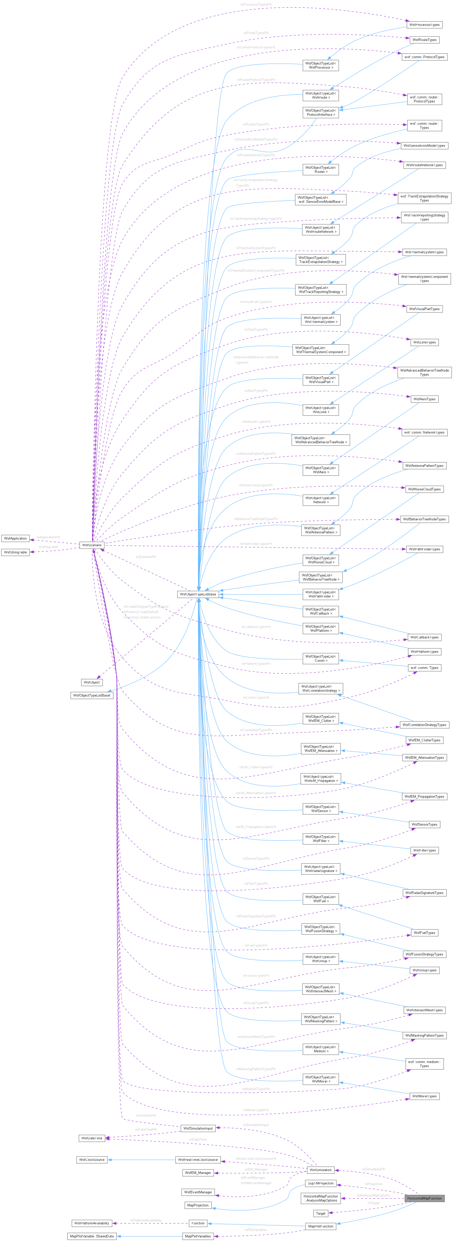
Classes | |
| struct | PointCompare |
| The function object for comparing two points at a specific variable index. More... | |
| struct | ContourLevel |
| A contour level for sedit contour level output. More... | |
| class | ContourFunction |
| The 'functor' for the contour filter. More... | |
| class | Selector |
| struct | AnalysisMapOptions |
Public Types | |
| using | Point = std::vector<double> |
| The list of values at a specified sample point. | |
Public Member Functions | |
| HorizontalMapFunction (const WsfScenario &aScenario) | |
| bool | Execute (WsfSimulation &aSimulation) override |
| bool | ProcessInput (UtInput &aInput) override |
| Process the horizontal_map input block. | |
| Public Member Functions inherited from MapPlotFunction | |
| MapPlotFunction ()=default | |
| MapPlotFunction (const WsfScenario &aScenario, const std::string &aScriptClassName="") | |
| virtual | ~MapPlotFunction ()=0 |
| bool | ProcessInput (UtInput &aInput) override |
| void | RegisterMapPlotVariable (const std::string &aVarName, std::shared_ptr< MapPlotVariable > aVariablePtr) |
| Public Member Functions inherited from Function | |
| Function (const Function &)=default | |
| Function (const WsfScenario &aScenario, const std::string &aScriptClassName="") | |
| virtual | ~Function ()=default |
| const std::string & | GetCommand () const |
| void | SetCommand (const std::string &aCommand) |
| const WsfScenario & | GetScenario () const |
| const std::string & | GetPlotName () const |
| const WsfPlatformAvailability & | GetPlatformAvailability () const |
| bool | IsPlatformAvailabilitySpecified () const |
| Has the user provided a platform_availability block for the plot? | |
Static Public Attributes | |
| static const double | cUNDEFINED = 1.0E+30 |
Protected Types | |
| using | SelectorList = std::vector<Selector> |
Protected Member Functions | |
| bool | BuildContours (size_t aPdVarIndex) |
| bool | LoopOverTargetAltitude (size_t aPdVarIndex) |
| bool | LoopOverTargetPitch (size_t aPdVarIndex) |
| bool | LoopOverTargetRoll (size_t aPdVarIndex) |
| void | ConvertCartesianToSpherical (double aDownRange, double aCrossRange, double &aLatitude, double &aLongitude) |
| Given a down range and cross range value from the sensor, compute the equivalent latitude and longitude. | |
| void | ConvertSphericalToCartesian (double aLatitude, double aLongitude, double &aDownRange, double &aCrossRange) |
| Given a latitude and longitude, compute the equivalent down range and cross range values. | |
| void | EvaluatePoint (double aSimTime, double aRowValue, double aColValue, std::vector< double > &aDataValues) |
| void | InitializeSensorPlatforms (double aSimTime) |
| void | CreateSensorList (WsfSimulation &aSimulation) |
| bool | InSelectorList (WsfSensor *aSensorPtr, const SelectorList &aSelectorList) |
| bool | ProcessTargetRegion (UtInput &aInput) |
| void | ReadSelector (UtInput &aInput, SelectorList &aSelectorList) |
| void | WriteDefendedAreaReport (const std::vector< double > &aAreaByPd) |
| Write the defended area report if requested. | |
| void | WriteGnuPlotFile (const std::vector< double > &aRowValues, const std::vector< double > &aColValues, const std::vector< Point > &aVarValues) |
| Write output gnuplot 'splot' output. | |
| void | WriteGnuPlotPlayerFile () |
| Write output gnuplot player location output. | |
| void | WriteKML_File (const std::vector< double > &aRowValues, const std::vector< double > &aColValues, const std::vector< Point > &aVarValues, size_t aVarIndex) |
| Write the KML output if requested. | |
| void | WritePdMapFile (const std::vector< double > &aRowValues, const std::vector< double > &aColValues, const std::vector< Point > &aVarValues, size_t aVarIndex) |
| Write the PdMap output if requested. | |
| void | WriteSeditContours (const std::vector< double > &aRowValues, const std::vector< double > &aColValues, const std::vector< Point > &aVarValues, size_t aVarIndex) |
| Write the scenario editor output if requested. | |
| void | WriteWSFContours (const std::vector< double > &aRowValues, const std::vector< double > &aColValues, const std::vector< Point > &aVarValues, size_t aVarIndex) |
| Write the scenario editor output if requested. | |
| void | WriteShapefile (const std::vector< double > &aRowValues, const std::vector< double > &aColValues, const std::vector< Point > &aVarValues, size_t aVarIndex) |
| Write the shapefile output if requested. | |
| void | WriteAnalysisMapFile (const std::vector< double > &aRowValues, const std::vector< double > &aColValues, const std::vector< Point > &aVarValues, size_t aVarIndex) |
| void | WriteTiffFile (const std::vector< double > &aRowValues, const std::vector< double > &aColValues, const std::vector< Point > &aVarValues) const |
| virtual void | WriteCustomOutputFormats (const std::vector< double > &aRowValues, const std::vector< double > &aColValues, const std::vector< Point > &aVarValues, size_t aVarIndex) |
| std::string | GetPdMapFileJsonMetadata () const |
Static Protected Member Functions | |
| static void | GreatCircleHeadingAndDistance (double aBegLat, double aBegLon, double aEndLat, double aEndLon, double &aHeading, double &aDistance) |
Additional Inherited Members | |
| Static Public Member Functions inherited from Function | |
| static bool | IsSensorPlotMode () |
Member Typedef Documentation
◆ Point
| using HorizontalMapFunction::Point = std::vector<double> |
The list of values at a specified sample point.
◆ SelectorList
|
protected |
Constructor & Destructor Documentation
◆ HorizontalMapFunction()
|
explicit |
References cUNDEFINED, mAnalysisMapOptions, MapPlotFunction::MapPlotFunction(), mAutomaticTargetCueing, mCenterEarthRadius, mCenterLat, mCenterLon, mContourLevels, mCrossRangeMax, mCrossRangeMin, mCrossRangeStep, mCrossRangeUnits, mDefendedAreaReportFile, mDownRangeMax, mDownRangeMin, mDownRangeStep, mDownRangeUnits, mExcludedSensors, mExclusionList, mFirstWrite, mGnuPlotFile, mGnuPlotPlayerFile, mHeaderLine1, mHeaderLine2, mHeaderLine3, mHeading, mInclusionList, mKML_File, mLatMax, mLatMin, mLatStep, mLineOfSightMasking, mLonMax, mLonMin, mLonStep, mModeIndex, mModeName, mOutputColumnLimit, mPdMapFile, Function::mPlatformAvailability, mProjection, mSeditFile, mSensorPlatformPitch, mSensorPlatformRoll, mSensorPlatformYaw, mSensors, mSensorToENU_Transform, mShapefile, mSimulationPtr, mTarget, mTargetAlt, mTargetAltAGL, mTargetAltMax, mTargetAltMin, mTargetAltRangeAGL, mTargetAltStep, mTargetPlatformId, mTiffFilename, mUseTM_Projection, and mWSF_File.
Member Function Documentation
◆ BuildContours()
|
protected |
References ConvertCartesianToSpherical(), cUNDEFINED, EvaluatePoint(), wsf::TerrainInterface::Get(), wsf::Terrain::GetElevInterp(), Function::GetScenario(), InitializeSensorPlatforms(), mAnalysisMapOptions, mCenterEarthRadius, mCenterLat, mCenterLon, mCrossRangeMax, mCrossRangeMin, mCrossRangeStep, mCrossRangeUnits, mDefendedAreaReportFile, mDownRangeMax, mDownRangeMin, mDownRangeStep, mDownRangeUnits, mGnuPlotFile, mGnuPlotPlayerFile, mHeading, mKML_File, mLatMax, mLatMin, mLatStep, mLonMax, mLonMin, mLonStep, mPdMapFile, MapPlotFunction::mPlotVariables, mProjection, mSeditFile, mSensors, mSensorToENU_Transform, mShapefile, mSimulationPtr, mTarget, mTargetAlt, mTargetAltAGL, mTiffFilename, mUseTM_Projection, mWSF_File, simTime, WriteAnalysisMapFile(), WriteCustomOutputFormats(), WriteDefendedAreaReport(), WriteGnuPlotFile(), WriteGnuPlotPlayerFile(), WriteKML_File(), WritePdMapFile(), WriteSeditContours(), WriteShapefile(), WriteTiffFile(), and WriteWSFContours().
Referenced by Execute(), and LoopOverTargetRoll().
◆ ConvertCartesianToSpherical()
|
protected |
Given a down range and cross range value from the sensor, compute the equivalent latitude and longitude.
References mCenterEarthRadius, mCenterLat, mCenterLon, mProjection, mSensorToENU_Transform, and mUseTM_Projection.
Referenced by BuildContours(), WriteAnalysisMapFile(), WriteKML_File(), WriteSeditContours(), WriteShapefile(), and WriteWSFContours().
◆ ConvertSphericalToCartesian()
|
protected |
Given a latitude and longitude, compute the equivalent down range and cross range values.
References mCenterEarthRadius, mCenterLat, mCenterLon, mProjection, mSensorToENU_Transform, and mUseTM_Projection.
Referenced by WriteGnuPlotPlayerFile().
◆ CreateSensorList()
|
protected |
References WsfComponentList::RoleIterator< T >::AtEnd(), WsfObject::GetName(), WsfSimulation::GetPlatformCount(), WsfSimulation::GetPlatformEntry(), InSelectorList(), WsfPlatformPart::IsTurnedOn(), mExcludedSensors, mExclusionList, mInclusionList, mSensors, platformPtr, and WsfSimulation::TurnPartOn().
Referenced by Execute().
◆ EvaluatePoint()
|
protected |
Determine the function value for a point.
This routine will perform a detection attempt from all sensors against the target. The return value is the selected function for the sensor that had the best probability of detection.
References WsfEM_Interaction::cRCVR_TERRAIN_MASKING, Utility::CueSensorToTarget(), WsfEM_Interaction::cXMTR_TERRAIN_MASKING, WsfMode::GetModeIndex(), WsfEM_Interaction::MaskedByTerrain(), mAutomaticTargetCueing, WsfEM_Interaction::mCheckedStatus, mDownRangeUnits, mExcludedSensors, WsfEM_Interaction::mFailedStatus, mLineOfSightMasking, mModeIndex, MapPlotFunction::mPlotVariables, mSensors, mSimulationPtr, mTarget, mTargetPlatformId, and settings().
Referenced by BuildContours().
◆ Execute()
|
overridevirtual |
Implements Function.
References WsfSimulation::AddPlatform(), BuildContours(), WsfObjectTypeList< T >::Clone(), CreateSensorList(), cUNDEFINED, Function::Execute(), WsfPlatformTypes::Get(), Function::GetCommand(), WsfSensor::GetModeCount(), WsfMode::GetModeIndex(), WsfSensor::GetModeIndex(), WsfObject::GetName(), WsfPlatformPart::GetPlatform(), WsfSimulation::GetPlatformByName(), WsfSimulation::GetScenario(), LoopOverTargetAltitude(), mAnalysisMapOptions, mContourVariable, mCrossRangeMax, mDefendedAreaReportFile, mDownRangeMax, mGnuPlotFile, mKML_File, mLatMax, mLonMax, mModeIndex, mModeName, mPdMapFile, Function::mPlatformAvailability, MapPlotFunction::mPlotVariables, mSeditFile, mSensors, mShapefile, mSimulationPtr, mTarget, mTargetPlatformId, mTiffFilename, mWSF_File, and WsfObject::SetName().
◆ GetPdMapFileJsonMetadata()
|
protected |
Returns the JSON metadata to be associated with a PD map output file. The metadata contains the name of the variable that the data pertains to as well as the names of the data that make up the X and Y axes. This metadata can be used to label the data in visualizations; e.g., in the IDE.
References mCrossRangeUnits, mDownRangeUnits, and MapPlotFunction::mPlotVariables.
Referenced by WritePdMapFile().
◆ GreatCircleHeadingAndDistance()
|
staticprotected |
◆ InitializeSensorPlatforms()
|
protected |
References WsfPlatformPart::GetPlatform(), mSensorPlatformPitch, mSensorPlatformRoll, mSensorPlatformYaw, mSensors, mSimulationPtr, and platformPtr.
Referenced by BuildContours().
◆ InSelectorList()
|
protected |
References HorizontalMapFunction::Selector::cPLATFORM_CATEGORY, HorizontalMapFunction::Selector::cPLATFORM_TYPE, HorizontalMapFunction::Selector::cSENSOR_CATEGORY, HorizontalMapFunction::Selector::cSENSOR_TYPE, WsfPlatformPart::GetPlatform(), WsfObject::GetTypeId(), and WsfPlatformPart::IsCategoryMember().
Referenced by CreateSensorList().
◆ LoopOverTargetAltitude()
|
protected |
References LoopOverTargetPitch(), mTargetAlt, mTargetAltAGL, mTargetAltMax, mTargetAltMin, mTargetAltRangeAGL, mTargetAltStep, and ok.
Referenced by Execute().
◆ LoopOverTargetPitch()
|
protected |
References LoopOverTargetRoll(), mTarget, and ok.
Referenced by LoopOverTargetAltitude().
◆ LoopOverTargetRoll()
|
protected |
References BuildContours(), mTarget, and ok.
Referenced by LoopOverTargetPitch().
◆ ProcessInput()
|
overridevirtual |
Process the horizontal_map input block.
Implements Function.
References Function::GetCommand(), mAnalysisMapOptions, mAutomaticTargetCueing, HorizontalMapFunction::AnalysisMapOptions::ColorRange::mColor, mContourLevels, mContourVariable, mDefendedAreaReportFile, mExclusionList, mGnuPlotFile, mGnuPlotPlayerFile, mHeaderLine1, mHeaderLine2, mHeaderLine3, mInclusionList, mKML_File, HorizontalMapFunction::ContourLevel::mLevel, HorizontalMapFunction::ContourLevel::mLineColor, mLineOfSightMasking, HorizontalMapFunction::ContourLevel::mLineWidth, HorizontalMapFunction::AnalysisMapOptions::ColorRange::mMaxValue, HorizontalMapFunction::AnalysisMapOptions::ColorRange::mMinValue, mModeName, mOutputColumnLimit, mPdMapFile, MapPlotFunction::mPlotVariables, mSeditFile, mSensorPlatformPitch, mSensorPlatformRoll, mSensorPlatformYaw, mShapefile, mTarget, mTargetAlt, mTargetAltAGL, mTargetAltMax, mTargetAltMin, mTargetAltRangeAGL, mTargetAltStep, mTargetPlatformId, mTiffFilename, mUseTM_Projection, mWSF_File, MapPlotFunction::ProcessInput(), ProcessTargetRegion(), and ReadSelector().
◆ ProcessTargetRegion()
|
protected |
Process target region definition commands. Formerly these could go only in a 'target_region' block, but now they can also appear outside the block. This makes it consistent with the vertical_map command where the region commands weren't bounded by a block. Requiring them to be in a block was kind of useless, so now we'll accept it either way.
References mCrossRangeMax, mCrossRangeMin, mCrossRangeStep, mCrossRangeUnits, mDownRangeMax, mDownRangeMin, mDownRangeStep, mDownRangeUnits, mLatMax, mLatMin, mLatStep, mLonMax, mLonMin, and mLonStep.
Referenced by ProcessInput().
◆ ReadSelector()
|
protected |
References HorizontalMapFunction::Selector::cPLATFORM_CATEGORY, HorizontalMapFunction::Selector::cPLATFORM_TYPE, HorizontalMapFunction::Selector::cSENSOR_CATEGORY, HorizontalMapFunction::Selector::cSENSOR_TYPE, HorizontalMapFunction::Selector::mType, and HorizontalMapFunction::Selector::mValue.
Referenced by ProcessInput().
◆ WriteAnalysisMapFile()
|
protected |
References ConvertCartesianToSpherical(), cUNDEFINED, mAnalysisMapOptions, mContourLevels, mCrossRangeMax, mCrossRangeMin, mDownRangeMax, mDownRangeMin, mHeaderLine1, mHeaderLine2, mHeaderLine3, mLatMax, mLatMin, mLonMax, mLonMin, and mSimulationPtr.
Referenced by BuildContours().
◆ WriteCustomOutputFormats()
|
inlineprotectedvirtual |
Referenced by BuildContours().
◆ WriteDefendedAreaReport()
|
protected |
Write the defended area report if requested.
References cUNDEFINED, mCrossRangeMax, mCrossRangeMin, mCrossRangeStep, mCrossRangeUnits, mDefendedAreaReportFile, mDownRangeMax, mDownRangeMin, mDownRangeStep, mDownRangeUnits, mLatMax, mLatMin, mLatStep, mLonMax, mLonMin, mLonStep, mSimulationPtr, mTarget, mTargetAlt, and mTargetAltAGL.
Referenced by BuildContours().
◆ WriteGnuPlotFile()
|
protected |
Write output gnuplot 'splot' output.
References cUNDEFINED, mCrossRangeUnits, mDownRangeUnits, mGnuPlotFile, mHeaderLine1, mHeaderLine2, mHeaderLine3, mLatMax, MapPlotFunction::mPlotVariables, and mSimulationPtr.
Referenced by BuildContours().
◆ WriteGnuPlotPlayerFile()
|
protected |
Write output gnuplot player location output.
References ConvertSphericalToCartesian(), cUNDEFINED, mCrossRangeUnits, mDownRangeUnits, mGnuPlotPlayerFile, mLatMax, mSimulationPtr, mTarget, and platformPtr.
Referenced by BuildContours().
◆ WriteKML_File()
|
protected |
Write the KML output if requested.
References ContourFilter2D::Contour(), ConvertCartesianToSpherical(), cUNDEFINED, mContourLevels, mCrossRangeMax, mCrossRangeMin, mDownRangeMax, mDownRangeMin, mHeaderLine1, mHeaderLine2, mHeaderLine3, mKML_File, mLatMax, mLatMin, mLonMax, mLonMin, mSimulationPtr, mTarget, and platformPtr.
Referenced by BuildContours().
◆ WritePdMapFile()
|
protected |
Write the PdMap output if requested.
References cUNDEFINED, GetPdMapFileJsonMetadata(), mCrossRangeUnits, mDownRangeUnits, mHeaderLine1, mHeaderLine2, mHeaderLine3, mLatMax, mOutputColumnLimit, mPdMapFile, and mSimulationPtr.
Referenced by BuildContours().
◆ WriteSeditContours()
|
protected |
Write the scenario editor output if requested.
References ContourFilter2D::Contour(), ConvertCartesianToSpherical(), cUNDEFINED, mContourLevels, mCrossRangeMax, mCrossRangeMin, mDownRangeMax, mDownRangeMin, mLatMax, mLatMin, mLonMax, mLonMin, mSeditFile, mSimulationPtr, mTarget, and platformPtr.
Referenced by BuildContours().
◆ WriteShapefile()
|
protected |
Write the shapefile output if requested.
References ContourFilter2D::Contour(), ConvertCartesianToSpherical(), cUNDEFINED, mContourLevels, mLatMax, mShapefile, and mSimulationPtr.
Referenced by BuildContours().
◆ WriteTiffFile()
|
protected |
References cUNDEFINED, mLatMax, mLatMin, mLonMax, mLonMin, MapPlotFunction::mPlotVariables, mSimulationPtr, and mTiffFilename.
Referenced by BuildContours().
◆ WriteWSFContours()
|
protected |
Write the scenario editor output if requested.
References ContourFilter2D::Contour(), ConvertCartesianToSpherical(), cUNDEFINED, Function::GetCommand(), mContourLevels, mCrossRangeMax, mCrossRangeMin, mDownRangeMax, mDownRangeMin, mFirstWrite, mLatMax, mLatMin, mLonMax, mLonMin, mSimulationPtr, mTarget, mTargetAlt, mWSF_File, and platformPtr.
Referenced by BuildContours().
Member Data Documentation
◆ cUNDEFINED
|
static |
◆ mAnalysisMapOptions
|
protected |
Referenced by BuildContours(), Execute(), HorizontalMapFunction(), ProcessInput(), and WriteAnalysisMapFile().
◆ mAutomaticTargetCueing
|
protected |
Referenced by EvaluatePoint(), HorizontalMapFunction(), and ProcessInput().
◆ mCenterEarthRadius
|
protected |
Referenced by BuildContours(), ConvertCartesianToSpherical(), ConvertSphericalToCartesian(), and HorizontalMapFunction().
◆ mCenterLat
|
protected |
Referenced by BuildContours(), ConvertCartesianToSpherical(), ConvertSphericalToCartesian(), and HorizontalMapFunction().
◆ mCenterLon
|
protected |
Referenced by BuildContours(), ConvertCartesianToSpherical(), ConvertSphericalToCartesian(), and HorizontalMapFunction().
◆ mContourLevels
|
protected |
◆ mContourVariable
|
protected |
Referenced by Execute(), and ProcessInput().
◆ mCrossRangeMax
|
protected |
◆ mCrossRangeMin
|
protected |
◆ mCrossRangeStep
|
protected |
Referenced by BuildContours(), HorizontalMapFunction(), ProcessTargetRegion(), and WriteDefendedAreaReport().
◆ mCrossRangeUnits
|
protected |
◆ mDefendedAreaReportFile
|
protected |
Referenced by BuildContours(), Execute(), HorizontalMapFunction(), ProcessInput(), and WriteDefendedAreaReport().
◆ mDownRangeMax
|
protected |
◆ mDownRangeMin
|
protected |
◆ mDownRangeStep
|
protected |
Referenced by BuildContours(), HorizontalMapFunction(), ProcessTargetRegion(), and WriteDefendedAreaReport().
◆ mDownRangeUnits
|
protected |
◆ mExcludedSensors
|
protected |
Referenced by CreateSensorList(), EvaluatePoint(), and HorizontalMapFunction().
◆ mExclusionList
|
protected |
Referenced by CreateSensorList(), HorizontalMapFunction(), and ProcessInput().
◆ mFirstWrite
|
protected |
Referenced by HorizontalMapFunction(), and WriteWSFContours().
◆ mGnuPlotFile
|
protected |
Referenced by BuildContours(), Execute(), HorizontalMapFunction(), ProcessInput(), and WriteGnuPlotFile().
◆ mGnuPlotPlayerFile
|
protected |
Referenced by BuildContours(), HorizontalMapFunction(), ProcessInput(), and WriteGnuPlotPlayerFile().
◆ mHeaderLine1
|
protected |
Referenced by HorizontalMapFunction(), ProcessInput(), WriteAnalysisMapFile(), WriteGnuPlotFile(), WriteKML_File(), and WritePdMapFile().
◆ mHeaderLine2
|
protected |
Referenced by HorizontalMapFunction(), ProcessInput(), WriteAnalysisMapFile(), WriteGnuPlotFile(), WriteKML_File(), and WritePdMapFile().
◆ mHeaderLine3
|
protected |
Referenced by HorizontalMapFunction(), ProcessInput(), WriteAnalysisMapFile(), WriteGnuPlotFile(), WriteKML_File(), and WritePdMapFile().
◆ mHeading
|
protected |
Referenced by BuildContours(), and HorizontalMapFunction().
◆ mInclusionList
|
protected |
Referenced by CreateSensorList(), HorizontalMapFunction(), and ProcessInput().
◆ mKML_File
|
protected |
Referenced by BuildContours(), Execute(), HorizontalMapFunction(), ProcessInput(), and WriteKML_File().
◆ mLatMax
|
protected |
Referenced by BuildContours(), Execute(), HorizontalMapFunction(), ProcessTargetRegion(), WriteAnalysisMapFile(), WriteDefendedAreaReport(), WriteGnuPlotFile(), WriteGnuPlotPlayerFile(), WriteKML_File(), WritePdMapFile(), WriteSeditContours(), WriteShapefile(), WriteTiffFile(), and WriteWSFContours().
◆ mLatMin
|
protected |
◆ mLatStep
|
protected |
Referenced by BuildContours(), HorizontalMapFunction(), ProcessTargetRegion(), and WriteDefendedAreaReport().
◆ mLineOfSightMasking
|
protected |
Referenced by EvaluatePoint(), HorizontalMapFunction(), and ProcessInput().
◆ mLonMax
|
protected |
◆ mLonMin
|
protected |
◆ mLonStep
|
protected |
Referenced by BuildContours(), HorizontalMapFunction(), ProcessTargetRegion(), and WriteDefendedAreaReport().
◆ mModeIndex
|
protected |
Referenced by EvaluatePoint(), Execute(), and HorizontalMapFunction().
◆ mModeName
|
protected |
Referenced by Execute(), HorizontalMapFunction(), and ProcessInput().
◆ mOutputColumnLimit
|
protected |
Referenced by HorizontalMapFunction(), ProcessInput(), and WritePdMapFile().
◆ mPdMapFile
|
protected |
Referenced by BuildContours(), Execute(), HorizontalMapFunction(), ProcessInput(), and WritePdMapFile().
◆ mProjection
|
protected |
Used for converting between X/Y and Lat/Lon. Only used when use_tm_projection input is true.
Referenced by BuildContours(), ConvertCartesianToSpherical(), ConvertSphericalToCartesian(), and HorizontalMapFunction().
◆ mSeditFile
|
protected |
Referenced by BuildContours(), Execute(), HorizontalMapFunction(), ProcessInput(), and WriteSeditContours().
◆ mSensorPlatformPitch
|
protected |
Referenced by HorizontalMapFunction(), InitializeSensorPlatforms(), and ProcessInput().
◆ mSensorPlatformRoll
|
protected |
Referenced by HorizontalMapFunction(), InitializeSensorPlatforms(), and ProcessInput().
◆ mSensorPlatformYaw
|
protected |
Referenced by HorizontalMapFunction(), InitializeSensorPlatforms(), and ProcessInput().
◆ mSensors
|
protected |
Referenced by BuildContours(), CreateSensorList(), EvaluatePoint(), Execute(), HorizontalMapFunction(), and InitializeSensorPlatforms().
◆ mSensorToENU_Transform
|
protected |
Referenced by BuildContours(), ConvertCartesianToSpherical(), ConvertSphericalToCartesian(), and HorizontalMapFunction().
◆ mShapefile
|
protected |
Referenced by BuildContours(), Execute(), HorizontalMapFunction(), ProcessInput(), and WriteShapefile().
◆ mSimulationPtr
|
protected |
Referenced by BuildContours(), EvaluatePoint(), Execute(), HorizontalMapFunction(), InitializeSensorPlatforms(), WriteAnalysisMapFile(), WriteDefendedAreaReport(), WriteGnuPlotFile(), WriteGnuPlotPlayerFile(), WriteKML_File(), WritePdMapFile(), WriteSeditContours(), WriteShapefile(), WriteTiffFile(), and WriteWSFContours().
◆ mTarget
|
protected |
◆ mTargetAlt
|
protected |
◆ mTargetAltAGL
|
protected |
Referenced by BuildContours(), HorizontalMapFunction(), LoopOverTargetAltitude(), ProcessInput(), and WriteDefendedAreaReport().
◆ mTargetAltMax
|
protected |
Referenced by HorizontalMapFunction(), LoopOverTargetAltitude(), and ProcessInput().
◆ mTargetAltMin
|
protected |
Referenced by HorizontalMapFunction(), LoopOverTargetAltitude(), and ProcessInput().
◆ mTargetAltRangeAGL
|
protected |
Referenced by HorizontalMapFunction(), LoopOverTargetAltitude(), and ProcessInput().
◆ mTargetAltStep
|
protected |
Referenced by HorizontalMapFunction(), LoopOverTargetAltitude(), and ProcessInput().
◆ mTargetPlatformId
|
protected |
Referenced by EvaluatePoint(), Execute(), HorizontalMapFunction(), and ProcessInput().
◆ mTiffFilename
|
protected |
Referenced by BuildContours(), Execute(), HorizontalMapFunction(), ProcessInput(), and WriteTiffFile().
◆ mUseTM_Projection
|
protected |
◆ mWSF_File
|
protected |
Referenced by BuildContours(), Execute(), HorizontalMapFunction(), ProcessInput(), and WriteWSFContours().
The documentation for this class was generated from the following files: